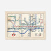
1947 London Underground Map
- Regular Price
- £12.80
- Sale Price
- £12.80
- Regular Price
- £16.00
- Unit Price
- per


Add 4 21x30cm Prints to your cart, and we'll add 4 frames absolutely FREE!
This 1947 London Underground map is a genuine snapshot of post-war transport history. Just two years after peace returned, Harry Beck's legendary design was still evolving, and this version captures the network as Londoners were rediscovering their city after years of blackouts and bomb shelters. It's cartography with character, a window into how the capital once moved.
The horizontal landscape format gives the map proper breathing room on your wall, making it ideal for anyone with London in their bones—whether you're nostalgic for the city, a design enthusiast, or simply fascinated by how transit systems have changed. Studying the routes and station names of nearly eighty years ago never gets old.
We print it on 230gsm fine art paper with archival pigment inks that resist fading for decades. Order it unframed in A4, A3, A2 or A1, or browse our solid wood frames—black, white, natural oak or gold ornate all complement vintage map prints beautifully. Everything's dispatched from Newcastle in a protective tube, ready to hang. This works as a gallery wall centrepiece or commanding solo above a desk, but it's particularly effective as a standalone statement piece that sparks conversation about London's transport heritage.
- FREE DELIVERY OVER £60 / $75 / €70
- PREMIUM MATTE ART PAPER
- FADE-RESISTANT INKS
- NO FUSS RETURN POLICY
We ship with Royal Mail and aim to deliver our products to the UK within 2-5 working days. International orders will take a few days longer depending on the location.
Free UK Shipping on all orders over £60