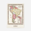
1863 Map of South America and Political Divisions
- Regular Price
- £12.80
- Sale Price
- £12.80
- Regular Price
- £16.00
- Unit Price
- per


Add 4 21x30cm Prints to your cart, and we'll add 4 frames absolutely FREE!
This South America map print captures the continent as it appeared in 1863, with political boundaries rendered in rich, period colours that feel authentically aged without looking tired. The cartography speaks to an era of exploration and shifting borders, making it genuinely engaging for history enthusiasts, geographers, or anyone drawn to the aesthetic of vintage mapmaking.
Printed on 230gsm fine art paper using professional giclée techniques and archival pigment inks, it's built to last far longer than the original it reproduces from. Available in A4, A3, A2 and larger formats, so you can choose the scale that suits your space. Each print is dispatched rolled in a protective tube from our Newcastle workshop.
Pair it with one of our solid wood frames—black, white, natural oak or gold ornate—for a gallery-ready finish, or display it unframed for a more contemporary look. Browse our vintage map prints to create a geography-themed gallery wall, or hang this alone to let the intricate colonial borders and layered history command the room.
- FREE DELIVERY OVER £60 / $75 / €70
- PREMIUM MATTE ART PAPER
- FADE-RESISTANT INKS
- NO FUSS RETURN POLICY
We ship with Royal Mail and aim to deliver our products to the UK within 2-5 working days. International orders will take a few days longer depending on the location.
Free UK Shipping on all orders over £60