17th Centure European Map
- Regular Price
- $17.30
- Sale Price
- $17.30
- Regular Price
- $22.00
- Unit Price
- per


Add 4 21x30cm Prints to your cart, and we'll add 4 frames absolutely FREE!
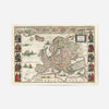
This 17th century European map captures the geographical imagination of an era when cartography was as much art as science. The soft, aged palette and hand-drawn details reveal how our ancestors understood the continent, complete with ornamental flourishes and curious blank spaces where knowledge simply ran out.
We print each one on 230gsm fine art paper using archival pigment inks, so the colours stay true and the detail stays crisp for decades. Available from A4 right up to 70x100cm, it scales beautifully across any wall. Browse our full collection of vintage map prints to discover other cartographic treasures from our archive.
Add a frame at checkout if you'd like it ready to hang—we offer solid wood frames in black, white, natural oak, and ornate gold finishes. Rolled carefully in a protective tube and dispatched from Newcastle, it arrives safely ready to display. Whether you're drawn to history, travel, or the romance of old maps, this print brings the kind of scholarly intrigue that rewards closer inspection year after year.
- FREE DELIVERY OVER £60 / $75 / €70
- PREMIUM MATTE ART PAPER
- FADE-RESISTANT INKS
- NO FUSS RETURN POLICY
We ship with Royal Mail and aim to deliver our products to the UK within 2-5 working days. International orders will take a few days longer depending on the location.
Free UK Shipping on all orders over £60